

Magnitude 7.0 Earthquake in Tibet Leaves at Least 16 Dead and Collapses Over 300 Homes
A shallow temblor struck Baqên County on Thursday night, injuring 32 people and severing power and communication lines across the mountainous region. The disaster represents the strongest earthquake in the area in five years, following deadly glacier-collapse floods on the plateau less than two months earlier.
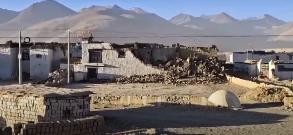
Thirty-two people were injured, with 11 sustaining severe injuries and 21 suffering minor injuries.12
At least 339 homes collapsed and 20 livestock shelters were destroyed across the affected communities.4
The tremor struck at a shallow depth of 10 kilometers in a sparsely inhabited mountainous zone.4
Story
A Magnitude 7.0 Earthquake Strikes Baqên County in TibetA powerful earthquake measuring magnitude 7 struck a rugged highland district of Tibet, causing at least 16 confirmed deaths according to reports issued by Chinese state media.1 The seismic disturbance happened late on a Thursday evening at approximately 10:33 p.m. local time, which corresponds to 1433 GMT, in the southwestern portion of Tibet.2 According to the state television broadcaster CCTV, this major rupture registered as the strongest seismic event to impact the broader region over the preceding five years.4 CCTV noted in its official reporting that the tremor also represented the most intense earthquake recorded anywhere within the borders of China since January 2024.4 The initial casualty threshold of 16 dead indicated the lethal nature of the shaking, which struck mountainous settlements during the late night while many residents were indoors.12
Official geographical determinations released by the Xinhua news agency, citing statements from the local emergency management bureau, identified Baqên County within the prefecture of Nagqu as the center of the earthquake.1 The emergency management bureau reported that this central impact zone in Baqên County is positioned 400 kilometers to the northeast of the regional capital of Lhasa.1 Offering an independent international measurement, the United States Geological Survey calculated that the epicenter lay approximately 190 kilometers east-northeast of Nagqu and 390 kilometers northeast of Lhasa.3 Both regional telemetry and broader monitoring established that the tectonic rupture manifested at a shallow depth of only 10 kilometers beneath the surface of the earth.4 Although this shallow depth focused energy directly into the surface terrain, the impact occurred within a mountainous district that is sparsely inhabited by human communities.4
In addition to the at least 16 individuals who lost their lives, official health and disaster tallies documented that 32 people were injured by the event.1 Detailed casualty assessments disclosed that among the 32 injured individuals, 21 people suffered minor injuries during the incident.2 The remaining 11 victims sustained severe physical injuries, requiring more intensive emergency medical interventions.2 Data supported the finding that more than one-third of the total injured individuals suffered from severe trauma rather than minor harm.1 Rescue contingents were dispatched into the disaster sector immediately after authorities declared an emergency to treat these injured victims and locate further casualties.1
Structural collapse across the affected localities was immediate, with initial reports indicating that over 300 houses had collapsed entirely under the force of the shaking.1 More specific surveys compiled by local officials raised that figure, confirming that at least 339 homes were brought down across the damaged settlements.4 The official damage tallies documented further losses beyond residential homes, recording the total destruction of 20 livestock shelters across the farming and pastoral areas.4 The simultaneous destruction of at least 339 residential properties and 20 animal facilities demonstrates the acute disruption inflicted upon community dwellings and agricultural shelter.4 These heavy building losses left many families without shelter in an environment where harsh mountainous conditions present immediate difficulties.14
Critical municipal and public utility networks were heavily disrupted across the region at the exact moment the earthquake shook the ground.14 Local dispatches reported that electrical power was largely severed across the affected communities, leaving vast swaths of the mountainous area in total darkness.1 State media reporting confirmed that both electrical power systems and telecommunication lines suffered severe, widespread outages throughout the impacted zone.4 The twin collapse of power transmission and telecommunications isolated damaged settlements from normal communication with outside monitoring agencies.4 With electrical power cut and communication links broken, emergency responders faced immense hurdles in establishing real-time updates regarding conditions on the ground.14
The shallow depth of 10 kilometers produced intense surface motion that rapidly altered the steep terrain of the mountainous region.4 Large volumes of falling rocks detached from the mountain slopes, resulting in widespread road closures along vital transportation routes.1 These rock-strewn corridors and highway blockages severely hindered rescue workers who were attempting to reach impacted mountain communities.1 The combination of severed roads and rugged geography physically isolated villages precisely when emergency help was most needed.14 Specialized rescue personnel were forced to deal with impassable mountain paths blocked by stone rubble as they tried to move heavy equipment into the disaster zone.1
Confronted with the scale of physical destruction and utility failure, regional government authorities formally declared an emergency across the affected jurisdiction.1 Following that official declaration, rescue teams were systematically mobilized and sent directly toward the disaster zone to conduct life-saving operations.1 The emergency management bureau focused operations around Baqên County within Nagqu, positioned approximately 400 kilometers northeast of Lhasa.1 Dispatched teams prioritized navigating obstructed roads to provide medical assistance to the 32 injured survivors and secure temporary protection for displaced households.12 Chinese state media monitored the deployment as emergency workers attempted to re-establish access to isolated mountain settlements.1
The magnitude 7 earthquake represents a significant seismic event when evaluated against recent tremor activity in Tibet and across China.14 State television network CCTV noted that this event was the most potent earthquake recorded in the area during the preceding five-year span.4 Furthermore, CCTV confirmed that the Baqên County tremor was the strongest earthquake registered in any part of China since January 2024.4 Despite its exceptional magnitude over that timeframe, the region had witnessed deadlier seismic events in recent months.4 Earlier in January 2025, an earthquake near Mount Everest in Tingri, Tibet, caused catastrophic casualties, killing no fewer than 126 people.4
The shock from the magnitude 7 tremor hit a broader geographical territory that was already grappling with devastating natural disasters.1 Under two months prior to this earthquake, massive floods triggered by glacier collapses and accompanying landslides swept through Tibet and Nepal.1 Those glacier-collapse floods and destructive landslides claimed at least 1,400 lives across the two adjoining regions.1 In addition to the 1,400 confirmed dead from those earlier disasters, hundreds of missing individuals remained completely unaccounted for.1 The arrival of a major earthquake in Baqên County thus piled additional trauma onto an alpine region still trying to absorb immense human and ecological losses.1
Historical records from the wider plateau demonstrate that shallow tremors of magnitude 7.1 can result in catastrophic casualty figures depending on population density.4 In the neighboring province of Qinghai, a 7.1-magnitude earthquake struck in 2010, resulting in the deaths of at least 2,698 people.4 In comparison, the earthquake centered in Baqên County had resulted in at least 16 fatalities according to the initial state media counts.1 While both events involved tremors of comparable magnitude, Baqên County is situated in a sparsely inhabited mountainous zone, which kept the initial fatality count far below the 2010 disaster in Qinghai.14 Nonetheless, with at least 339 homes destroyed and 32 people injured, the earthquake has dealt a severe blow to the communities of southwestern Tibet.124
Disagreements
Where the sources do not matchEpicenter distance northeast of Lhasa
Xinhua1
US Geological Survey3
Possibly: Different seismic monitoring agencies and regional bureaus utilized independent telemetry baselines to determine the distance from Lhasa.
History
How it came to this- 2010Deadly Qinghai earthquakeA 7.1-magnitude earthquake struck neighboring Qinghai province, killing at least 2,698 people.
- January 2025Tingri earthquake near Mount EverestAn earthquake near Mount Everest in Tingri, Tibet, killed no fewer than 126 people.
- Under two months priorGlacier collapse floods and landslidesGlacier-collapse floods and landslides across Tibet and Nepal claimed at least 1,400 lives with hundreds missing.
- 2026-10-23Magnitude 7 earthquake strikes Baqên CountyA shallow magnitude 7 earthquake struck Baqên County in Tibet, causing at least 16 fatalities and 32 injuries.
- Nowat least 16 Fatalities from the magnitude 7 earthquake in Tibet
Impact
Spreading outward, level by level- Level 1Immediate building destruction and utility disruption
At least 339 homes collapsed and 20 livestock shelters were destroyed, while electricity and telecommunications were severed across the impacted zone.14
Fact - Level 2Transportation blockage and emergency mobilization
Falling rocks caused road closures that obstructed rescue workers dispatched under a declared emergency from reaching isolated communities.1
Fact - Level 3Heightened vulnerability in an already disaster-hit highland region
With more than a third of injured victims severely hurt and hundreds left shelterless, relief operations face severe alpine hurdles in an area coping with catastrophic flood losses from weeks earlier.
Analysis
Sources
What each source supportsWritten by AI from the sources listed below: every fact was checked word for word against its source, and inference is marked apart. How we write